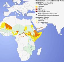
Aiding relief efforts during famine

Monitoring hydroclimate extremes helps decision-makers reduce famine in developing countries. Researchers at UC Santa Barbara, in collaboration with the US Geological Survey and the Famine Early Warning Systems Network, have been investigating and monitoring the physical and social variables affecting food security and growing practices.
Investigator:
Greg Husak
Assistant Researcher
University of California, Santa Barbara
Project description:
The Climate Hazards Group (CHG) at the Department of Geography, University of California Santa Barbara has developed a nearly decade-long relationship with the U.S. Geologic Survey and Famine Early Warning Systems Network investigating and monitoring the physical and social variables affecting food security in the developing world. The CHG research team is tasked with developing new techniques for monitoring food security to provide advanced information to FEWS NET regarding their relief activities. This work is primarily done through leveraging remotely sensed data to monitor rainfall, crop conditions, and hydrologic and climate information to accurately depict ground conditions. The outcomes of this research have had profound effects on decision making regarding relief efforts to the developing world, practices for rainfall monitoring both internationally and domestically, as well as supporting ten graduate students in their pursuit of advanced degrees over the course of the project.
Select publications:
Hoell, A., C. Funk, and M. Barlow. 2013. The Regional Forcing of Northern Hemisphere Drought During Recent Warm Tropical West Pacific Ocean La Nina Events. Climate Dynamics 10.1007/s00382-013-1799-4
Hoell, A., M. Barlow, and R. Saini. 2013. Intraseasonal and seasonal-to-interannual Indian Ocean convection and hemispheric teleconnections. Journal of Climate 10.1175/JCLI-D-12-00306.1
Mordecai, E., K.Paaijmans, L.Johnson, C. Balzer, T. Ben-Horin, E. de Moor, A.McNally, S. Pawar, S.Ryan, T.Smith, K.Lafferty. 2012. Physiological constraints dramatically lower the expected temperature for peak malaria transmission. Ecology Letters
Jankowska, M.M., D. Lopez-Carr, D. Funk, G.J. Husak, and Z.A. Chafe. 2012. Climate change and human health: Spatial modeling of water availability, malnutrition, and livelihoods in Mali, Africa. Applied Geography 33:4-15.
Tarnavsky E., M. Mulligan, and G.J. Husak, 2012. Spatial disaggregation and intensity correction of TRMM-based rainfall time series for hydrological applications in Dryland Catchments. Hydrological Sciences Journal 57(2):248-264.
Grace, K., G. Husak, L. Harrison, D. Pedreros, and J. Michaelsen. 2012. Using High Resolution Satellite Imagery to Estimate Cropped Area in Guatemala and Haiti. Applied Geography 32(2):433-440.
Marshall M., G.J. Husak, J. Michaelsen, C. Funk, D. Pedreros, and A. Adoum. 2011. Testing a High Resolution Satellite Interpretation Technique for Crop Area Monitoring in Developing Countries. International Journal of Remote Sensing 32(3):7997-8012, 10.1080/01431161.2010.532168.
Williams, A., C. Funk, J. Michaelsen, S. Rauscher, I. Robertson, T. Wils, M. Koprowski, Z. Eshetu, and N. Loader. 2011. Recent summer precipitation trends in the Greater Horn of Africa and the emerging role of Indian Ocean sea surface temperature. Climate Dynamics 10.1007/s00382-011-1222-y.
Williams, A.P., C.D. Allen, C. Millar, T. Swetnam, J. Michaelsen, C.J. Still, and S.W. Leavitt. 2011. Forest responses to increasing aridity and warmth in southwestern North America. Proceedings of the National Academy of Sciences 107(50):21289-21294.
Williams, A.P., J. Michaelsen, S.W. Leavitt, and C.J. Still. 2011. Using tree-rings to predict the response of tree growth to climate change in the continental United States during the 21st century. Earth Interactions 14(19):1-20.
Harrison, L., J. Michaelsen, C. Funk, and G. Husak. 2011. Effects of temperature changes on maize production in Mozambique. Climate Research 46(3):211-222.
Husak G.J., J. Michaelsen, P. Kyriakidis, J.P. Verdin, C. Funk, and G. Galu. 2011. The Forecast Interpretation Tool ? a Monte Carlo Technique for blending climatic distributions with probabilistic forecasts. International Journal of Climatology 31(3):461-467, 10.1002/joc.2074.
Williams, A.P. 2011. Forest responses to warming on the Sky Islands of the Southwestern United States. Mountain Views 5(1):24-28.
Carbone, M.S., A. Ambrose, T.E. Dawson, A.P. Williams, C.M. Boot, S.M. Schaeffer, J.P. Schimel, and C.J. Still. 2011. Seasonal and episodic moisture controls on plant and microbial contributions to soil respiration. Oecologia 10.1007/s00442-011-1975-3.
Williams, A.P. and C. Funk. 2011. A westward extension of the warm pool intensifies the Walker circulation, drying eastern Africa. Climate Dynamics 10.1007/s00382-010-0984-y.
Wandiga, S., M. Opondo, D. Olago, A. Githeko, F. Githui, M. Marshall, et al. 2010. Vulnerability to epidemic malaria in the highlands of Lake Victoria basin: The role of climate change/variability, hydrology and socio-economic factors. Climate Change 99:473-497.
Marshall, M. 2010. Agricultural Drought Monitoring with Land Data Assimilation and Remote Sensing, in Remote Sensing of Drought: Innovative Monitoring Approaches, edited by M. Anderson and J. Verdin, p. 270, Taylor and Francis, London, United Kingdom.
Williams, A.P. and C. Funk. 2010. A westward extension of the tropical Pacific warm pool leads to March through June drying in Ethiopia and Kenya. USGS Open-File Report. http://pubs.usgs.gov/of/2010/1199/
Husak, G.J,. M.T. Marshall, J. Michaelsen, D. Pedreros, C. Funk, G. Galu. 2008. Crop area estimation using high and medium resolution satellite imagery in areas with complex topography. Journal of Geophysical Research 113:D14112.
