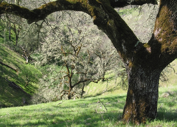
I am standing where stream flow begins, in a nameless tributary of the Russian River to the east of Hopland, California. This particular spot and location has been a grazing livestock ranch, primarily sheep, going back more than 100 years. This is one of thousands of spots in the watershed where water comes to the surface, joins in a channel, and starts its path downstream.
Many of us have stood at a confluence of two rivers or an estuary where a watershed's outfall meets an ocean. These locations are the stream's or river's end, their terminus. Where I am standing now is instead the headwaters of the stream system, where water is initially released and visible as a thin, shallow, bouncing band.
Watersheds collect, store, and transport water. The transport function is performed by streams and rivers. These are dynamic, pervious channel networks, each with a beginning and an end. At any part of the network, the channel is that lowest point in the landscape, stretching from one stream bank to the other, and generally widening in the downstream direction, until the stream mouth empties into another water body.
At the other end of a network is the channel head, where the channel begins. This is where I am standing. Channel heads are found in small intimate folds in the landscape. These depressions are referred to by many names—draws, bowls, hollows—the place in hills where the slopes become shallow and coalesce.
Like an amphitheater, the surrounding hillslopes rise around me. Reaching out at shoulder height, I can almost touch these slopes. The mixed oak woodland and interspersed grasslands are in attendance across these slopes. Ghost pines, live oaks, black oaks, and madrones, among other trees, make their stand interspersed with annual and perennial grasses blanketing the ground.
This mosaic of vegetation is hosted and sustained by the complex mix of marine sediments that have been pushed up, forming these hills, and erosion carving the stream channel. Below the surface are soils one to the three feet deep that have developed from the underlying geology.
It's March 3, 2019 and on the cusp of spring. Between the light breezes, the stream water sings its way downstream. I think back to the intense storms that moved across this part of California the week before and the resulting floods in the lower portion of the Russian River. Those and earlier winter storms soaked into the soil until the soil reached its capacity to hold water.
Once the soils were primed, water was released to the channel network. That water is still being released now, days later, and will be for several more months into May or even June. Rainfall for this area and most of California has been substantial, matching amounts not seen since 1983, and definitively ending the nearly 5-year drought. This contrast in extremes is the norm for California, meaning the next drought or next flood is only a year away.
Downstream, the Russian is perennial, flowing year-round. But here at the channel head, flow is intermittent on an annual cycle. Rains begin in the fall, with headwater surface flows starting in late fall or early winter, once soils are saturated. This wetting up process reverses in the spring, until the channel head is dry.
At some point this year, flow in the headwaters will stop. Saturated soils releasing water laterally below the ground surface will gradually release less and less water to the channel. Trees and grasses will demand more and more water as they leaf out and grow. As soils pores empty of free water, the remaining moisture is held more tightly to soil particles and plant root surfaces through a physical tension. Eventually the channel head will run dry.
While you may not have the opportunity to visit a channel head and experience the place where stream flow starts and stops each year, you are often closer to one than you think. Driving a rural road or hiking in a favorite park or open space will invariably find you crossing one of these unnamed headwater streams. As you do, give a look upstream, from where the water going past you has come. Up the channel into the bowl is one of the channel heads and headwaters for the watershed you are in.
I don't know when I will get to this channel head again. However, this place where surface flow is initiated will be close in my mind, particularly, as I visit the confluences and estuary of the Russian River, during the wet and dry periods and high and low rainfall years to come.
***
I have the privilege of engaging California's communities with the aspiration of safeguarding the sustenance and well-being that its oak-woodland watersheds and the people that are a part of them provide. This millennia long integrated relationship of humans and land has parallel histories in other Mediterranean parts of the world.
This is the first of occasional installments about working Mediterranean landscapes in California and around the globe. Combined they will explore the concepts of watershed functions, working landscapes, and Mediterranean climate, vegetation, and management. Join me in experiencing these settings, growing our appreciation for the integrated nature of these landscapes and people, and gaining understanding and tools for our tenure as stewards.
To learn more about these specific watersheds and research conducted in them this article is suggested. If interested in learning how stream flow is generated in California oak woodland watersheds you may want to read this article.
